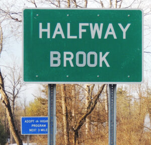
Teri Rogers, Warren County Historical Society executive director, shares a letter saying that as of Oct. 8, the 31-mile stream running from Queensbury to Kingsbury to Fort Ann is officially Halfway Brook.

“We are pleased to inform you that the U.S. Board of Geographic Names, at its October 8, 2020, meeting, approved your proposal to change the name of Halfway Creek in Washington County and Warren County to Halfway Brook,” said the letter from Jennifer E. Runyon, “Research Staff, U.S. Board on Geographic Names.
“The change has been entered into the Geographic Names Information System, the nation’s official geographic names repository, which is available and searchable online at https://usgs.gov/geonames/domestic-names.”
In 2008, The Chronicle first raised the issue of the stream’s name after two readers told us angrily the state Department of Transportation had installed “Halfway Creek” signs on Ridge Road (Route 9L) near the new bridge over the waterway.
“I’ve always known it as Halfway Brook. I have never heard it called Halfway Creek,”
Dr. Marilyn Van Dyke, Queensbury town historian and executive director of the Warren County Historical Society, said then.
In 2013, New York agreed to shift it back to Halfway Brook. Now the U.S. agrees. The new entry in the Geographic Names Information System elaborates:
“Halfway Brook: stream; 31 mi. long; heads in the Town of Queensbury at Wilkie Reservoir…flows SE then generally NE through the Town of Kingsbury and the Town of Fort ann to enter the Champlain Canal at Fort Ann; named for the stream’s location about halfway along a military road between Fort William Henry on Lake George and Fort Edward on the Hudson River; Washington and Warren County, New York: …
“Not: Blood Brook, Clear River, Forks Creek, Half Way Brook, Half Way Creek, Half Way Run, Halfway Creek, Halfway Run, Half-Way Brook, Half-Way Creek, Half-Way Run, Helf Creek, Seven Mile Creek, Schoone Creek, Scoon Creek, Scoune Creek, Shone Creek.”
Copyright © 2020 Lone Oak Publishing Co., Inc. All Rights Reserved.
 Glens Falls Chronicle Serving the Glens Falls/Lake George region; Warren, Washington and northern Saratoga counties since 1980

